read the article
Postings from the Visual Communication Design Program in the School of Design at San Francisco State University.
Showing posts with label maps. Show all posts
Tuesday, March 27, 2012
Map Of Energy Consumption In Every Single NYC Building
A new map by the School of Engineering and Applied Science at Columbia University gives us a picture of energy consumption in the five boroughs of New York, on a block-by-block basis. It’s kind of like Google Maps for spotting the greediest energy hogs of the city (and it won’t surprise you that Manhattan is, by far, the biggest spender). You can zoom all the way down to your own building, if you’re so inclined, and see how your building stacks up.
Tuesday, October 4, 2011
Studio Tours: Stamen | AIGA San Francisco
Tuesday, 11 Oct 2011
6:00pm - 8:00pm
Tours sell out early, so get your tickets today!
Join us as we get a behind-the-scenes look at the inner workings of five influential Bay Area design studios during our Fall / Winter Studio Tours. See projects in progress, learn about different firms’ cultures and methodologies, and rub elbows with design luminaries and up-and-comings in the environment that inspires their best work.
Tuesday, 11 Oct 2011
6:00pm - 8:00pm
Tours sell out early, so get your tickets today!
Join us as we get a behind-the-scenes look at the inner workings of five influential Bay Area design studios during our Fall / Winter Studio Tours. See projects in progress, learn about different firms’ cultures and methodologies, and rub elbows with design luminaries and up-and-comings in the environment that inspires their best work.
Labels:
AIGA,
data visualization,
design,
Lecture,
maps,
technology
Wednesday, March 23, 2011
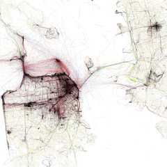
Using Flickr Geotags to Map the World's Cities
Photographer Eric Fischer uses Flickr's geotags to create city maps that show the places of intense human interest.
Labels:
data visualization,
digital,
geography,
graphics,
information design,
maps,
technology,
urbanism
Monday, March 21, 2011
200th Birthday for the Map That Made New York
By SAM ROBERTS
Published: March 20, 2011
Henry James condemned it a century ago as a “primal topographic curse.” Rem Koolhaas, the architect and urbanist, countered that its two-dimensional form created “undreamed-of freedom for three-dimensional anarchy.” More recently, two historians described its map, regardless of its flaws, as “the single most important document in New York City’s development.”
read the article
Interactive historic maps
Subscribe to:
Posts (Atom)